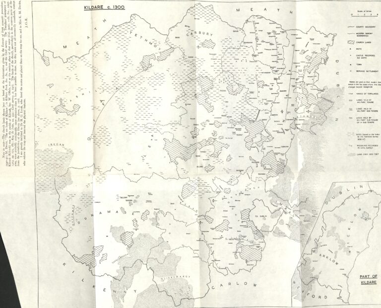
Map of Kildare c. 1300

Map of Kildare c. 1300
(Taken from Jocelyn Otway-Ruthven’s ‘The medieval county of Kildare’, Irish Historical Studies, Vol. XI, No. 43, 1959).
The above article ‘The medieval county of Kildare’ by the late historian Annette Jocelyn Otway-Ruthven appeared in the March 1959 volume of Irish Historical Studies. It sets out the evolution of the part of Leinster that was to become Kildare from the time of the Norman invasion when the areas was divided into four tribal territories, to the early 14th century onwards when the author states that Kildare was administered as a royal county dominated by the power and possessions of the earls of Kildare.
The article itself is available to read and download through the JSTOR Ireland Collection (available for free via AskAboutIreland website).
The JSTOR digitised version does not clearly re-produce the accompanying map insert however. It is now re-produced below, scanned from the original hard copy volume included in the Kildare Local Studies collections. It includes much interesting topographical and other information including church and military lands in County Kildare c. 1300. As the note to the map states (left-hand side), this map was compiled by Otway-Ruthven based on information provided in other sources. The well known archaeologist Harold Graham (H.G.) Leask assisted the author in placing the motes, while Mrs. K. M. (Kathleen Mary?) Davies is credited for redrawing and map and inserting the physical features.

